Monday, July 23, 2012

Indian Village of Ahwahnee


Behind the Museum is The Indian Village of Ahwahnee which is a recreation of an Indian settlement in the Yosemite Valley, we left the museum through the back door and found ourselves in the village. A nice welcome sign greeted us at the beginning of the trail.


Among the many exhibits we saw the Sweat house which is heated by an oak-wood fire. The deer hunters would spend up to three hours inside then emerge and bath themselves. Then, they rubbed themselves with wormwood or another aromatic plant to remove human scent and allow the hunters to get closer to their quarry.
This particular sweat house replaced several earlier sweat houses that stood on this site and was built on a framework of four incense cedar poles covered with successive layers of buchbrush.


The Ceremonial Roundhouse serves as the center for the village religious activities to date. Since roundhouses need reconstruction every dozen years or so this structure was built in 1992 and replaced the one that was built in 1973.  It was built using four big oak posts for support, and the roof is constructed of incense cedar bark. The entrance is located on the southeast side of the structure facing the morning sun.


Next exhibit was the Miwok Cabin depicting the way Miwok people used to live. We learned from the posted information that Miwok cabin came to existence soon after non-Indian came to Yosemite in 1850’s and settle there. The local Indian people begun to emulate the building style of these settlers and that’s how these cabins came to existence.


Next exhibit was the Chief’s House, and reading the information we learned that Miwok leaders had large homes than others in the village, for they often hosted dinners and events for large groups of people and by the turn of the century many Miwok people built structures like this one: they were based on Miwok homes, but built using Euro-American technology.


Next we saw a re-created Umatchas which was considered a typical Miwok and Paiute early home and was made from cedar bark. It gave us a taste of how the Miwok and Paiute peoples lived; the places where they prepared and cooked their food, and more.


Another exhibit in the village was the Acorn Granary which used to store Black oak acorns. The granaries were raised above the ground on stumps and consisted of a nest-like containers made from grapevines and buck brush. The cavity was lined with wormwood and then filled with acorns. The entire granary was then shingled with conifer boughs and capped at the top with layers of more boughs, cedar bark, and after the coming of non-Indians, canvas.

Yosemite Falls


As soon as we got off the shuttle we hiked on a paved trail through wooded area leading to the Lower Yosemite Falls. Tall trees surrounded us and it was nice to hear the birds whistling along the way. Luckily the trail wasn’t so busy and there was very light traffic.


Crossing the first wooden bridge that spans over the Yosemite Creek on our way to the falls.


…and there they were: the Upper Yosemite Falls and The Lower Yosemite Falls right underneath. What a picture, no wonder why they’re so popular.


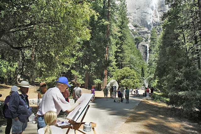
The view of those two falls was spectacular and there were some artists who stood there and painted them.


The Lower Yosemite Falls attracts a lot of attention because it is easily accessible. The viewing area was refurbished recently to accommodate the crowds and it was busy. Many visitors like to hike on the boulders all the way to the bottom of that falls (pay attention to the tiny specs close to the bottom of the falls) despite the warning signs.


The view from the bridge is spectacular and draws a crowd. Luckily we got a viewing spot right as we got there because a few minutes later it was so crowded we couldn’t even get closer.

On our way back we saw a bunch of very young sequoia’s thriving on the side of the trail. Looks like the new generation of sequoias are coming up.

Before we knew it we were back in the shuttle bus station on our way back. Another adventure comes to an end.

Mirror Lake


Last year when we visited Mirror Lake it was late August and this lake was a mire puddle, so we figure this year since we’re going to visit Yosemite at the beginning of June there will be more water in this lake. Not even close, looks like the water evaporated faster than you can possible think, and again we face with an empty lake with some puddles here and there. It was a real disappointment but we try to make the best out of it. 


Soon as we got of the shuttle we start hiking about a mile toward the lake.


The paved road is the trail itself and we didn’t encounter any traffic on it back or fourth.


About half a mile before the lake there is a bike rack where you leave your bike and hike the rest of the way to the lake.


Along the road runs the Tenaya Creek which forms interesting mini waterfall and a whole array of colors as it journey down between the rocks.


This is the disappointing picture we found soon as we arrived to the lake. Even though it was early in the season, still most of the water evaporated and only a few puddles left.

Water was ankle deep and people just walk there back and fourth wetting their ankle in the cold water or whatever left of it.


We walked around trying to find a nice spot to take a picture that will resemble any mirror view of what it suppose to look, and that is the best we could come up with, Bummer!


Luckily we saw a bunch of Swallow Tail butterflies which stole the show with their nectar collecting skills display.


Since there was not much to see in Mirror Lake we hiked back and hop on the shuttle to our next destination.

A long face that displays the pleasure of almost dry Mirror Lake, maybe next time will be luckier.

The John Muir Trail


After spending about 3 hours on top of Nevada Falls, eating lunch, taking a million pictures and enjoying the scene it was time to head back. We chose to hike down on the John Muir Trail which is longer than the Mist Trail and provide us with more spectacular views of Nevada Falls and the valley below.


Right as we started the hike we encountered a flooded trail and needed to exercise more caution hiking on the stones to avoid getting our shoes wet, not to mention injured.


The trail wound itself around in such a way to create a panoramic view of Nevada Falls, water is dripping down from the top of the walls (It’s raining, it’s raining…) and creates little puddles along the way. We exercised more caution to avoid slipping down and getting wet. The scene was gorgeous and worth all the effort.

This particular area is very popular and attracts visitors from around the world who stop to take their pictures with Nevada Falls in the background.


Part of the trail is being used for transporting freight or horse riding and the right of way is always to the horses and mules, so when we encountered this mule train coming we gave them the right of way of course.


Continuing hiking the trail we reached a set of switchbacks which seems nice and stony.

One last look at Nevada Falls before we start descending toward the valley floor.


Navigating through a set of switchbacks toward the valley floor.


We reached Clark Point where trail to Vernal Falls is to the right and trail to the valley floor is to the left. We took the left trail on our way down to the valley floor.

…and the fun continued as we navigated our way amidst the stones, keeping a close eye were we set our foot as to avoid any mishap or injury.

We got stuck behind a passenger mule train that made their way too slowly and caused a bunch of hikers to come into a crawl behind. So the leader stop the train and let us cut true a side stair case in order to pass them and that was very nice gesture on part of the leader and helped us reach our destination without delay.


Continuing on our way down, getting close to our destination, the valley floor.


Finally we reached the valley floor near the Vernal Falls bridge where we started our hike that morning. Amy and Jacob took one last picture before we reached our car and went home.

Friday, July 20, 2012

The Mist Trail (Part 3) - Nevada Falls


We had a good break at the top of Vernal Falls, ate our breakfast and rested our legs. Of course we didn’t feed any wild animals because we want to preserve nature and keep them wild. They kept approaching us again and again with that begging look on their faces but we didn’t give in.


About half an hour later we were off on our way again continuing to hike the Mist Trail which turns into rocky surfaces on our way up to Nevada Fall.


The trail started to look more like this, the section which was bare and rocky absorbed lots of heat from the sun and we felt it especially that morning. Good thing we were wore sunscreen.


The trail took another turn up and become a little bit challenging requiring us to exercise more endurance. We were extra careful hiking on the stone stairs and watched carefully were we stepped.


Then we reached the Nevada Fall Bridge which overlooks the gushing water coming from the fall and continued underneath to the Emerald Pool and the Vernal Fall down below.
The scene was spectacular and we asked ourselves where all this water end up? Is used for irrigation? There is a lot of water that can be put into good use.


As we continued climbing the trail winds itself into a wooded, shaded area were we got some relief from the heat and had a chance to catch our breath.


We entered the last part of the Mist Trail less than a hundred yards below Nevada Falls itself. The view is awesome, water cascading down, cooling up the air even though we were hiking in the hot sun; it felt good to know we are almost at the top. 


This is the last push and it looks like Amy took it in stride and kept pushing.


And finally we reached the top of Nevada Falls.


The bridge over the fall with Liberty Cap in the background. Last time we saw Liberty Cap was when we viewed it from Glacier Point earlier, it looks much different when you stand so close to it.


Jacob set up for the pictures.


Scenes like this are worth all the efforts and it can only be seen in Yosemite National Park.
Water gushing underneath the bridge on their way down


After spending about 3 hours at the top of Nevada Fall it was time to head back, only this time we will hike down about 2.5 miles on the John Muir Trail.